Wetland Park Ecological Environment Monitoring and Protection and Ecological Restoration Project
square
case
meter
Draw
book
Tianjin Zhiyi Times Technology Development Co., Ltd.
I. Project Background
Wetland is closely related to the reproduction, survival and development of human beings. It is one of the most important environmental capitals of human beings. It is also an ecosystem rich in biodiversity and higher productivity in the natural world. It has enormous economic, social and environmental value. In recent years, as one of the contracting parties to the “Wetlands Conventionâ€, the Chinese government attached great importance to the protection, development, and rational use of wetland resources, and even deployed a series of protection work.
However, due to the early days, people’s ignorance of the environment, the limitations of their understanding, and the pure pursuit of economic interests have long been a result of numerous factors such as cofferdams, infrastructure occupation, environmental pollution, over hunting, siltation, unreasonable water conservancy projects and many other factors. Under the superimposed effect, the wetland resources suffered severe and irreversible damage.
As a result, the wetland is a unique ecological environment formed by the interaction of hydrology, soil, atmospheric composition, and microclimate, and any change in the factors that make up this environment will lead to changes in the wetland ecosystem. Therefore, when it When disturbed by natural or human activities, the stability of the ecosystem is damaged to a certain extent, which in turn affects the structure of the biological community. Wetland ecosystems disappear, deteriorate, and degrade at a speed that is visible to the naked eye, causing great harm to the economy and society. sustainable development.
Therefore, on the basis of adopting protective measures for wetlands, a complete monitoring system for wetlands should be established to fully understand the dynamic changes of wetlands and provide timely and accurate reference materials for wetland management, scientific research, effective management and control, and rational use of wetlands. Maintaining ecological functions of wetlands and realizing sustainable economic development are of great significance. As a national wetland park approved for establishment by the State Forestry Administration for the purpose of protecting wetland ecosystems, rationally utilizing wetland resources, and conducting public education and scientific research on wetlands, it is also the “pioneer†of perfecting the monitoring system.
Second, project analysis
2.1 Purpose of Wetland Park Monitoring
1. Grasp its dynamic changes, predict development trends, regularly provide dynamic monitoring data and monitoring reports, analyze the causes of changes, and put forward countermeasures and suggestions for wetland protection and rational use, and provide decision-making basis for wetland management and rational use.
2. Combine key wetland surveys and fixed monitoring sites to provide services for wetland management in various departments.
3. Based on this research, it provides the basis for the future environmental assessment of wetland development and utilization, and effectively analyzes the feasibility of various wetland resources development and utilization projects.
2.2 Monitoring basis
Ambient Air Quality Standard GB3095-1996
Surface water environmental quality standard GB3838-2002
Soil Environmental Quality Standard GB15618 1995
Notice of the State Forestry Administration on Printing and Distributing the "Measures for the Administration of National Wetland Parks" Lin Wet Hair [2017] No. 150
"AQI Technical Regulations (Trial)" HJ633-2012
"General Specification for Air Ion Measuring Instrument" GB/T18809-2002
"Water Quality Sampling Plan Design Regulations" GB/T12997-91
Water Quality Sampling Technical Guidelines GB/T12998-91
"Surface Water Environmental Quality Standard" GB38382002
"Water Pollution Source and Online Monitoring System Installation Technical Specifications" HJ/T353-2007
"Technical Specifications for Acceptance of Water Pollution Source Online Monitoring System" HJ/T354-2007
"Technical Specifications for Operation and Assessment of Water Pollution Source Online Monitoring System" HJ/T355-2007
“Technical Specifications for the Validity of Water Pollution Source Online Monitoring Data†HJ/T356-2007
“Data Transmission Standards for Pollution Sources and Online Automatic Monitoring (Monitoring) System†HJ/T104-2003
"Regulations for Instrument Power Supply Design" HG/T20509-2000
"Data transmission standard of pollution source online automatic monitoring (monitoring) system" HJ/T212-2005
"Environmental Pollution Source Automatic Monitoring Information Transmission and Exchange Technical Specifications" HJ-T352-2007
"Soil Environmental Monitoring Technical Specifications" HJ/T166-2004
2.3 The main content of monitoring
The monitoring of wetlands mainly follows the general principles of ecology and the theory of nature reserves. Based on the characteristics of the structures and functional areas of wetland ecosystems, the monitoring of wetlands will focus on the development of monitoring in terms of biology, ecology, limnology, hydrology, and environmental science. index. Seize the information flow, energy flow, material flow transmission and relatedness of each trophic level in the ecosystem, and focus on protecting endangered species, protecting species diversity, and protecting the integrity and structure of natural ecosystems. Eco-balance is more sensitive to ecological factors, taking into account social and economic factors. The specific contents include natural environment factors, dynamic changes in biodiversity, wetland development and utilization, and threatened conditions, changes in wetland management, socio-economic development around wetlands, and specific indicators specific to different wetland types. These can be divided into the following aspects:
2 The type, area and distribution of wetlands;
2 The air quality of wetlands;
2 Status of water resources in wetlands;
2 Wetland land resources status;
2 Main environmental factors affecting the dynamic changes of wetlands.
2 Wetland biodiversity and its rare and endangered wild animals and plants;
2 The impact of social and economic development in wetland surrounding wetland resources;
2 Wetland management status and research status;
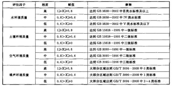
Therefore, in the monitoring system, it mainly includes air, water quality, soil, and video surveillance. According to the National Wetland Park Assessment Criteria and various elements of monitoring indicators and other related documents, the specific monitoring factors are determined as follows:
2 weather monitoring: temperature, humidity, atmospheric pressure, wind speed, wind direction, etc.
2 Air environment monitoring: total suspended particulate matter, inhalable particulate matter, SO2, CO2, NOx, O3, negative oxygen ions, etc.
2 Water environment monitoring: COD, ammonia nitrogen, pH, water temperature, flow, dissolved oxygen, etc.
2 Soil environmental monitoring: Soil pH, trace elements (cadmium, mercury, arsenic, lead, etc.), temperature, humidity, illuminance, etc.
2 Environmental Quality: Noise
2 video surveillance
Third, the system overview
The environmental monitoring system provided in this case is a practical automatic monitoring system for wetland monitoring users. It sets the monitoring parameters of the “big three of gas, water, and earth†and builds an “ecological environment monitoring platform integrating land and seaâ€. .
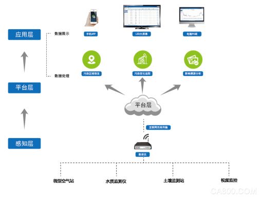
The entire system consists of three parts: the perception layer, the platform layer, and the application layer.
Among them, the sensory layer consists of weather monitoring stations, micro-air monitoring stations, water quality monitors, soil monitoring stations, video monitoring and other front-end monitoring equipment, and transmits monitoring data of each monitoring equipment to the central platform through a wireless network.
The platform layer receives real-time data from the sensing layer for analysis, and uses big data analysis for data processing and aggregation collation.
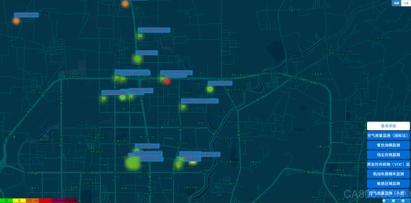
In the application layer, the GIS method can directly and visually display the air quality status of each monitoring point and the entire area, and the concentration level of pollutants, and provide various services such as abnormal alarms and regional air quality changes.
3.1 System Features
1) Comprehensively monitor all aspects of wetland park environmental factors, such as weather, noise, water environment, soil environment and air environment quality.
2) Set up a pollution warning release system to assist emergency management of protected areas
3) Cloud service platform, B/S architecture software platform, which can view, download and analyze data at any time.
4) Gather 100 experts and use advanced international technology to ensure the accuracy, stability, and environmental tolerance of the sensor.
5) RTU (telemetric data acquisition) Highly integrated with traditional data collectors, data transmission units, batteries, etc., IP67 waterproof, strong field resistance.
6) The data has RTU, gateway and server level 3 cache, and the breakpoint data is actively resumed to ensure that the integrity of the data is not lost.
7) Support data transmission protocol encryption, ensure data transmission security, and not be maliciously intercepted and parsed.
8) The platform is powerful, stable, user-friendly and exquisite
9) Mobile point and fixed site cooperation, comprehensive monitoring, improve efficiency
3.2 System Composition
1) Cloud platform, server, LED display screen
2) Monitoring station: water quality monitor, automatic meteorological/soil monitoring station, miniature air station, etc.
3) Others: drones, patrol electric vehicles, integrated birdwatching cameras, binoculars, Serfaces
Fourth, platform software system
Zhiyi Times Grid Management Platform System is based on the “Environmental Information Network Construction Specification†(HJ460-2009), “Technical Specifications for Environmental Protection Application Software Development and Management†(HJ622-2011), and “online automatic monitoring and monitoring of pollution sources†issued by the National Environment Department. The system data transmission standard 2122005, and the "National Environmental Pollution Source Automatic Monitoring Information Transmission and Exchange Technical Specifications" (HJ-T352-2007) and other national standard protocols are based on the data sensing system of each monitoring point and are aimed at different environmental enterprises and institutions. , The use of the latest environmental protection theory research results and information technology, the establishment of intelligent environmental protection grid online monitoring system data platform.
The platform data center can provide real-time collection and transmission of data and video of each monitoring point in the region, real-time monitoring of wetland environmental quality, online data query and report statistics, automatic data warning, comprehensive analysis of environmental protection information, data collection and ranking feedback, etc. Provide information resources and means for environmental research, and provide a unified management platform for environmental protection business management.
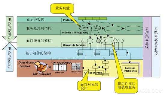
The overall design of the technical route is as follows:
Adopt B/S structure.
SOA architecture
The platform can be configured through the application framework unified portal, unified user management and unified rights management, basic data management
XML-based data exchange specification
Component development
V. Front-end equipment system
Monitoring data includes: temperature, humidity, wind speed, wind direction, atmospheric pressure, total suspended particulate matter, inhalable particulate matter, SO2, CO2, NOx, O3, negative oxygen ions, COD, ammonia nitrogen, pH, water temperature, flow, dissolved oxygen, soil pH Values, cadmium content, mercury content, temperature and humidity, illuminance, noise and video monitoring, etc. All monitoring data can be adjusted according to the actual needs of users.
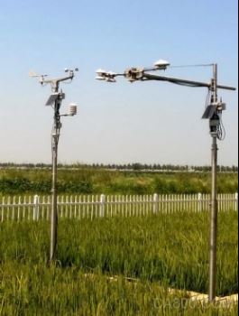
5.1 Weather Station
According to the user's needs, a variety of meteorological sensors can be selected to meet the needs of different fields such as scientific research, agriculture, forestry, environmental protection, transportation, photovoltaic, etc. It is a fully automatic weather station, data wireless transmission, users can log on the server to view, analyze, download data online . Products are solid, difficult to use, stable, and the beasts of the user trust.
Optional sensors: temperature and humidity, wind speed, direction, rainfall, atmospheric pressure, evaporation, total carbon dioxide radiation, photosynthetically active radiation, sunshine hours, net radiation, ultraviolet radiation, soil moisture content, soil temperature, soil heat flux, visibility, Blood God, road temperature, etc.
Applications: scientific research, agriculture, forestry, environmental protection, transportation, nature reserves, photovoltaic power generation
5.3 Water Quality Monitoring Station
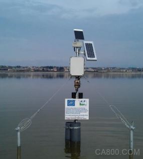
Multi-parameter water quality sensor is selected according to the user's needs to meet the water quality monitoring of rivers, lakes, surface water, and groundwater. The data is transmitted wirelessly. The user can log on the server to view online, backwash, and download data.
Optional sensors: COD, ammonia nitrogen, pH, dissolved oxygen, turbidity, depth, temperature, salt (conductance), ORP, chlorophyll a, blue-green algae, ammonium, ammonia, nitrate, chloride, rhodamine WT
Applications: groundwater monitoring, surface water monitoring, lake reservoirs and reservoir monitoring, drinking water safety monitoring, irrigation water monitoring
5.4 Negative oxygen ion monitoring station
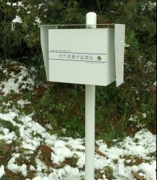
This product is a set of high-precision atmospheric negative ion monitor, in line with internationally accepted technical specifications, all technical indicators have reached the international advanced level. The product uses a unique collection tube capacitor and a purely imported signal processing unit, with high ionic charge conversion efficiency and stable charge acquisition. It has the characteristics of strong anti-interference ability, strong anti-rain ability, stable communication, high test precision, strong environmental adaptability, and long-term uninterrupted work in the field.
5.5 Air Quality Monitoring Station
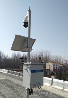
The cost of this kind of product independently developed by our company is 3 to 5 times lower than the traditional reference station built based on the analyzer. Compared with cheaper alternative products on the market, not only can grid platforms provide a strong data foundation, but also can be calibrated according to the site to ensure that it has the best traceability.
Options include: standard pollutants ozone (O3), nitrogen dioxide (NO2), nitrogen oxides (NOx), carbon monoxide (CO), sulfur dioxide (SO2), particulate matter (PM10, PM2.5), volatile organic compounds ( VOC), hydrogen sulfide (H2S), carbon dioxide (CO2); and meteorological parameters such as noise, temperature, humidity, wind speed, wind direction, and barometric pressure.
5.6 drone
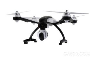
Our company has specially developed a smart “Four gas and two dust†sensor assembly for gas monitoring in the atmosphere. The sensor of this component adopts a highly sensitive imported electrochemical sensor and adopts a diffusion type gas detection method. The operation is convenient, the measurement is accurate, the work is reliable, and the volume is light and small. The dedicated bracket designed by us can be easily installed on a drone, utilizing no one. The unique advantages of the machine enable gas monitoring of airborne trajectories. At the same time, we use our software platform to integrate real-time monitoring and 3D visualization of parameters such as latitude, longitude, altitude, aircraft status, temperature, humidity, PM2.5, PM10, CO, O3, SO2, NO2, CO2, and VOC. Provide an effective monitoring method for air quality analysis in three-dimensional space.
5.7 patrol electric car
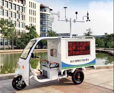
This product is a new generation of high-precision internet of things monitoring products developed on the basis of 3G/4G mobile internet platform, and it complies with GB3096-2008 Acoustic Environmental Quality Standard and GB3095-2012 Ambient Air Quality Standard. This product can include 3G/4G data transmission unit, GPS positioning unit, particle monitoring unit, noise monitoring unit, meteorological environment monitoring unit, video monitoring and storage unit, LED display unit and other units, mainly used in urban functional area monitoring, The industrial enterprise's boundary monitoring and construction field monitoring field provides relevant law enforcement agencies with real-time monitoring data and picture evidence.
5.8 Video Monitoring Unit
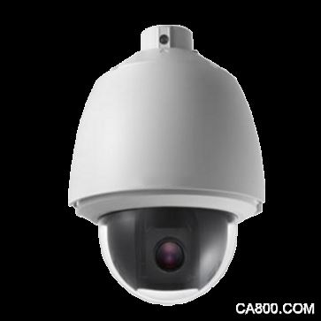
In the above device monitoring terminal can be integrated video surveillance camera. The platform-based management mode is the core video surveillance system. It adopts a dedicated video compression chip, and the image is clear. The image adopts the H.264 image compression method that is self-optimized, and the video compression efficiency is high. Standard resolution 1280 * 720 pixels, up to 1920 * 1080 pixels, and can be customized. With audio interface, support audio and video transmission monitoring at the same time.
a) The monitoring data can be superimposed on the video screen, so that the central monitoring system can monitor the image information and monitoring data information in real time, and can achieve the time-sharing and over-standard image capture functions.
b) View the camera video image corresponding to it through the selected device, and the device with pan/tilt can control the camera pan tilt to freely adjust the viewing position.
Plc Splitter,Mini Steel Plc Splitter,Mini Optical Plc Splitter,Bare Fiber Plc Splitter
ShenZhen JunJin Technology Co.,Ltd , https://www.jjtcl.com